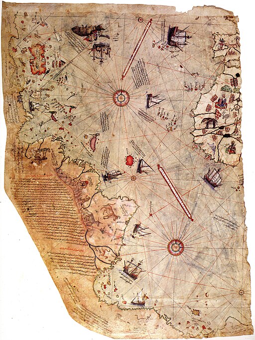
The Piri Reis Map is a world map compiled in 1513 by the Ottoman admiral and cartographer Piri Reis. Only one-third of the map has survived. This map is the oldest known Turkish atlas showing the New World, and one of the oldest maps of America still in existence.
The Piri Reis Map shows the western coasts of Europe and North Africa and the coast of Brazil with amazing accuracy. Various Atlantic islands, including the Azores and the Canary Islands, are depicted.
The map demonstrates the extent of global exploration of the New World by approximately 1510. Piri also stated that he had used Arab sources and Indian maps sourced from the Portuguese, including Christopher Columbus’s map of the Americas.
The map is the surviving western third of a world map drawn on gazelle skin parchment, with dimensions of approximately 90 cm × 63 cm.
The surviving portion of the map details the western coast of Africa and the eastern coast of South America.
The map was signed by Piri Reis, an Ottoman-Turkish admiral, geographer and cartographer, and dated to the Islamic year 919 AH, equivalent to 1513 AD.
It was presented to Ottoman Sultan Selim I in 1517. In the map’s legend, Piri inscribed that the map was based on about twenty charts and medieval European maps of the world.
According to Piri, these maps included eight Ptolemaic maps, an Arabic map of India, four newly drawn Portuguese maps, and a map by Christopher Columbus of the western lands.
Piri Reis’s inscription reads:
“From eight Jaferyas of that kind and one Arabic map of Hind [India], and from four newly drawn Portuguese maps which show the countries of Sind, Hind and Çin [China] geometrically drawn, and also from a map drawn by Qulūnbū [Columbus] in the western region, I have extracted it. By reducing all these maps to one scale, this final form was arrived at, so that this map of these lands is regarded by seamen as accurate .. of the Seven Seas on the maps described above.”
There is some scholarly debate over which charts and maps in Piri’s inscriptions are included in the eight Ptolemaic maps, the four Portuguese maps, the Arabic map, and the Columbus map.
The Piri Reis Map contains numerous discrepancies. However, the depiction of the Antarctic coast has created most of the extreme theories and debates. (See videos below)
Piri Reis Map Discovery
The map was discovered serendipitously in 1929, through the work of the German theologian who had been commissioned by the Turkish authorities to catalog the Topkapı Palace library’s non-Islamic items.
The discovery caused an international sensation, as it represented the only then known copy of a world map of Christopher Columbus (1451–1506), and was the only 16th-century map that showed South America in its proper longitudinal position to Africa.
Geographers had spent several centuries unsuccessfully searching for a “lost map of Columbus” that was supposedly drawn while he was in the West Indies. Much of the Caribbean is mapped fairly accurately and appears to reflect Columbus’s maps of the area.
The map was depicted on the reverse of the Turkish 10 million lira banknote of 1999-2005 and then the 10 lira banknote of 2005-2009.
Piri Reis
Ahmed Muhiddin Piri (1465 – 1553), better known as Piri Reis was an Ottoman admiral, navigator, and cartographer.
He is primarily known today for his maps and charts collected in his “Book of Navigation,” a book that contains detailed information on navigation, as well as very accurate charts.
He gained fame as a cartographer when a small part of his first world map prepared in 1513 was discovered in 1929 at the Topkapı Palace in Istanbul.
He was executed in 1553 in Cairo, having been found guilty of raising the siege of Hormuz Island. Even though his reasons were the lack of maintenance and supplies for his ships.
Piri Reis is mentioned in several video games and puzzle games. (See video below)

6th-century copy of the 1525 “Book of Navigation” by Piri Reis, Library of Istanbul University
- Title: Piri Reis Map
- Dated: 1513
- Period: Ottoman
- Discovered: 1929 in Topkapı Palace Library, Istanbul
- Materials: Gazelle skin parchment
- Dimensions: Originally 90 cm × 63 cm, only 1/3 survives today
- Type: Ancient and Historical Maps
- Museum: Topkapi Palace Museum
Piri Reis Map explained
500TH ANNIVERSARY OF PIRI REIS MAP OF 1513
Virtual Tour of Prehistoric Art and Ancient Artifacts
- Ain Sakhri Lovers
- Wolverine Pendant of Les Eyzies – Prehistoric Portable Art
- Antler Perforated Baton – Paleolithic Portable Art
- Venus of Brassempouy
- Head of a Cycladic Statue, Keros-Syros Culture
- Stargazer – Sculpture of a Female Figure
- Stargazer Figurine
- Dancing Girl (Mohenjo-Daro) from the Indus Valley Civilization
- Prehistoric Stone Hand Axe
- Great Handaxe from Furze Platt
- Clovis Weapons and Tools
- Neolithic Chinese Painted Pottery
- Korean Neolithic Pot
- Neolithic Pottery from Ban Chiang
- Li – Chinese Tripod Jar
- Comb-Pattern Pottery
- Phaistos Disc
- Sican Funerary Mask – Peru
- Greenstone Mask, Central America
- Australian Aboriginal Rock Art – Bradshaw Rock Paintings
- Indigenous Australian Rock Art – Wandjina Style
Ottoman admiral and cartographer Piri Reis Maps of the World & Antarctica
Archaeology Project – “Piri Reis Map – 1513”
Virtual Tour of Important Historical Artifacts
- Prehistoric Stone Hand Axe – 2.6 Million Years Ago
- Narmer Palette – 3,100 BC
- The Stargazer (Statuette of a Woman) – 3000 BC
- Neolithic Painted Pottery – 2,500 BC
- Dancing Girl (Mohenjo-Daro) – 2,500 BC
- Li – Chinese Tripod Jar – 2,300 BC
- Treasure from Troy – 2,200 BC
- Gudea, Prince of Lagash – 2,120 BC
- Law Code of Hammurabi – 1,750 BC
- Nebra Sky Disk – 1600 BC
- Mask of Agamemnon – 1,500 BC
- The Sphinx of Hatshepsut – 1,470 BC
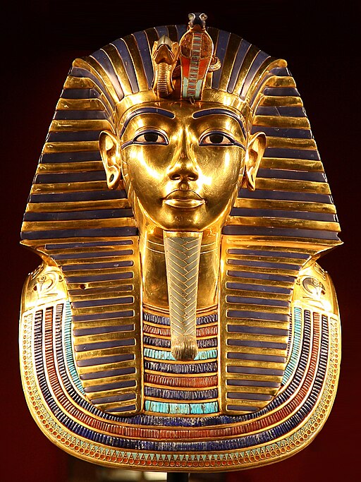
- Tutankhamun’s Mask – 1,323 BC
- Mummy of Katebet – 1,300 BC
- Book of the Dead – Papyrus of Ani and Hunefe – 1,250 BC
- Avanton Gold Cone – 1250 BC
- Relief of a Winged Genie – 880 BC
- Siloam Inscription – 700 BC
- The Lion Hunt – 640 BC
- Ishtar Gate – 575 BC
- The Curse of the Tabnit Sarcophagus – 500 BC
- Kleroterion – 470 BC
- The Parthenon Marbles – 440 BC
- The Alexander Sarcophagus – 300 BC
- The Winged Victory of Samothrace – 200 BC
- The Rosetta Stone – 196 BC
- The Pergamon Altar – 150 BC
- Antikythera Mechanism – 100 BC
- The Temple of Dendur – 10 A.D.
- James Ossuary – 1st-century
- Lindow Man – 2 BC and 119 AD
PIRI REIS 1513: A Introduction to Spatial analysis
Virtual Tour of Famous Maps
- Jacques-Nicolas Bellin Map of the Straits of Malacca
- Abraham Ortelius Map of Southeast Asia
- Meto Navigation Chart
- Stick Chart for Sea Navigation
- Ptolemy’s View of the Solar System
- Piri Reis Map
- Babylonian Map of the World – Imago Mundi
- Ancient and Historical Maps
- Theatrum Orbis Terrarum
“How Did They Make Those Maps”
Assassin’s Creed: The Real History – “Piri Reis”
~~~
“You can’t use an old map to explore a new world.”
– Albert Einstein
~~~
Photo Credit: 1)Piri Reis / Public domain
Popular this Week


 Sponsor your Favorite Page
 SEARCH Search for: Search Follow UsJoin – The JOM Membership Program
Sponsor a Masterpiece with YOUR NAME CHOICE for $5
Share this:
- Tweet
