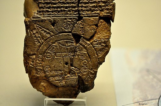
This Babylonian Map of the World is a clay tablet containing a labeled depiction of the known world, with a partially surviving description, dated to roughly the 6th century B.C.
The map is circular with two outer defined circles. The plan is centered on the Euphrates, flowing from the north to the south of the map. The city of Babylon is shown on the Euphrates, north of the center of the map.
The cuneiform script labels on locations inside the circular map, as well as a few regions outside, make this ancient tablet one of the oldest usable maps.
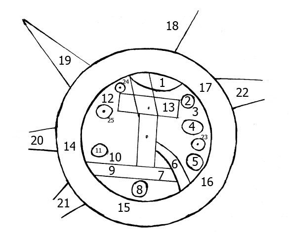
The mouth of the Euphrates is labeled “swamp” and “outflow.” Susa, the capital of Elam, is shown to the south. Urartu to the northeast and Habban, the capital of the Kassites, is shown to the northwest.
There are seven small interior circles at the perimeter areas within the outer ring, and they appear to represent seven cities.
The parallel lines at the bottom seem to represent the southern marshes, and a curved line coming from the north, northeast appears to represent the Zagros Mountains.
The two outer circles represent water in between and are labeled as “bitter river,” referring to the salt sea. The circular Ocean surrounds Mesopotamia, and eight “regions” are depicted as triangular sections.
The description of five of these regions has survived, and their depiction as triangles might indicate that they were symbolized as mountains.
The tablet was discovered at Sippar, some 60 km north of Babylon on the east bank of the Euphrates River. The text was first translated in 1889.
The cuneiform text describes the eight regions, and it details the strange and mythical beasts, as well as great heroes who lived there, although the text is not complete.
The hole at the center of the tablet is a “firing hole,” deliberately made by the scribe. Similar holes appear in the middle of the text above the map and at two points on the reverse.
The map is an example of ancient geography, and the places are shown in their approximately correct positions. However, the other essential purpose of the tablet was to explain the Babylonian mythological world.
Babylonian Map of the World
- Mountain”
- City
- Urartu
- Assyria
- Der
- Not Known
- Swamp
- Susa (capital of Elam)
- Canal “outflow.”
- Bit Yakin
- City
- Habban
- Babylon, divided by the Euphrates
- – 17. Ocean “saltwater.”
18 – 22. outer “Regions.”
23 – 25. No or missing description.

Babylonian Map of the World
- Title: Babylonian Map of the World – Imago Mundi
- Dated: 6th century B.C.
- Writing: cuneiform
- Period: Neo-Babylonian or early Achaemenid period
- Discovered: Sippar, Tell Abu Habbah near Yusufiyah, Iraq
- Materials: Clay
- Dimensions: Height: 12.2 cm (4.8 in); Width: 8.2 cm (3.2 in)
- Type: Ancient and Historical Maps
- Museum: British Museum
The Babylonian Map of the World
Virtual Tour of Prehistoric Art and Ancient Artifacts
- Ain Sakhri Lovers
- Wolverine Pendant of Les Eyzies – Prehistoric Portable Art
- Antler Perforated Baton – Paleolithic Portable Art
- Venus of Brassempouy
- Head of a Cycladic Statue, Keros-Syros Culture
- Stargazer – Sculpture of a Female Figure
- Stargazer Figurine
- Dancing Girl (Mohenjo-Daro) from the Indus Valley Civilization
- Prehistoric Stone Hand Axe
- Great Handaxe from Furze Platt
- Clovis Weapons and Tools
- Neolithic Chinese Painted Pottery
- Korean Neolithic Pot
- Neolithic Pottery from Ban Chiang
- Li – Chinese Tripod Jar
- Comb-Pattern Pottery
- Phaistos Disc
- Sican Funerary Mask – Peru
- Greenstone Mask, Central America
- Australian Aboriginal Rock Art – Bradshaw Rock Paintings
- Indigenous Australian Rock Art – Wandjina Style
The Babylonian Map of the World or Imago Mundi
Virtual Tour of Important Historical Artifacts
- Prehistoric Stone Hand Axe – 2.6 Million Years Ago
- Narmer Palette – 3,100 BC
- The Stargazer (Statuette of a Woman) – 3000 BC
- Neolithic Painted Pottery – 2,500 BC
- Dancing Girl (Mohenjo-Daro) – 2,500 BC
- Li – Chinese Tripod Jar – 2,300 BC
- Treasure from Troy – 2,200 BC
- Gudea, Prince of Lagash – 2,120 BC
- Law Code of Hammurabi – 1,750 BC
- Nebra Sky Disk – 1600 BC
- Mask of Agamemnon – 1,500 BC
- The Sphinx of Hatshepsut – 1,470 BC
- Tutankhamun’s Mask – 1,323 BC
- Mummy of Katebet – 1,300 BC
- Book of the Dead – Papyrus of Ani and Hunefe – 1,250 BC
- Avanton Gold Cone – 1250 BC
- Relief of a Winged Genie – 880 BC
- Siloam Inscription – 700 BC
- The Lion Hunt – 640 BC
- Babylonian Map of the World Tablet – 550 BC
- Ishtar Gate – 575 BC
- The Curse of the Tabnit Sarcophagus – 500 BC
- Kleroterion – 470 BC
- The Parthenon Marbles – 440 BC
- The Alexander Sarcophagus – 300 BC
- The Winged Victory of Samothrace – 200 BC
- The Rosetta Stone – 196 BC
- The Pergamon Altar – 150 BC
- Antikythera Mechanism – 100 BC
- The Temple of Dendur – 10 AD
- James Ossuary – 1st-century
- Lindow Man – 2 BC and 119 AD
Top 12 Inventions and Discoveries of Ancient Babylonia
Virtual Tour of Famous Maps
- Jacques-Nicolas Bellin Map of the Straits of Malacca
- Abraham Ortelius Map of Southeast Asia
- Meto Navigation Chart
- Stick Chart for Sea Navigation
- Ptolemy’s View of the Solar System
- Piri Reis Map
- Babylonian Map of the World – Imago Mundi
- Ancient and Historical Maps
- Theatrum Orbis Terrarum
Babylon: A History of the City
~~~
“You can’t use an old map to explore a new world.”
– Albert Einstein
~~~
Photo Credit: 1)Osama Shukir Muhammed Amin FRCP(Glasg) / CC BY-SA (creativecommons.org/licenses/by-sa/4.0); EvgenyGenkin / Public domain;
Popular this Week


 Sponsor your Favorite Page
 SEARCH Search for: Search Follow UsJoin – The JOM Membership Program
Sponsor a Masterpiece with YOUR NAME CHOICE for $5
Share this:
- Tweet
