The earliest known world maps date to classical antiquity, the oldest examples of the 6th centuries BC were based on the flat Earth paradigm. World maps with a spherical Earth first appear in the Hellenistic period.
The developments in Greek geography culminated with Ptolemy’s world map in the 2nd century, which would remain authoritative throughout the Middle Ages.
Increasing knowledge on the size of the Earth allowed cartographers to indicate the parts of the world map not yet explored as terra incognita.
During the Age of Discovery, in the 15th to 18th centuries, world maps became increasingly accurate.
Exploration of Antarctica, Australia, and Africa by western mapmakers was completed in the 19th and early 20th century.
Virtual Tour of Ancient and Historical Maps
- Babylonian Map of the World – Imago Mundi
- Piri Reis Map
- Jacques-Nicolas Bellin Map of the Straits of Malacca
- Abraham Ortelius Map of Southeast Asia
- Meto Navigation Chart
- Stick Chart for Sea Navigation
- Ptolemy’s View of the Solar System
- Theatrum Orbis Terrarum
- Borgia Map
Highlights Tour of Ancient and Historical Maps
Babylonian Map of the World – Imago Mundi
This Babylonian Map of the World is a clay tablet containing a labeled depiction of the known world, with a partially surviving description, dated to roughly the 6th century B.C.
The map is circular with two outer defined circles. The plan is centered on the Euphrates, flowing from the north to the south of the map. The city of Babylon is shown on the Euphrates, north of the center of the map.
The cuneiform script labels on locations inside the circular map, as well as a few regions outside, make this ancient tablet one of the oldest usable maps.
The mouth of the Euphrates is labeled “swamp” and “outflow.” Susa, the capital of Elam, is shown to the south. Urartu to the northeast and Habban, the capital of the Kassites, is shown to the northwest.
Piri Reis Map
The Piri Reis Map is a world map compiled in 1513 by the Ottoman admiral and cartographer Piri Reis. Only one-third of the map has survived. This map is the oldest known Turkish atlas showing the New World, and one of the oldest maps of America still in existence.
The Piri Reis Map shows the western coasts of Europe and North Africa and the coast of Brazil with amazing accuracy. Various Atlantic islands, including the Azores and the Canary Islands, are depicted.
The map demonstrates the extent of global exploration of the New World by approximately 1510. Piri also stated that he had used Arab sources and Indian maps sourced from the Portuguese, including Christopher Columbus’s map of the Americas.
The map is the surviving western third of a world map drawn on gazelle skin parchment, with dimensions of approximately 90 cm × 63 cm.
Jacques-Nicolas Bellin Map of the Straits of Malacca
“Jacques-Nicolas Bellin Map of the Straits of Malacca,” is a maritime map of Singapore and Governor’s Straits dating to 1755.
This map shows landmarks along the western coast of the Malay Peninsula, including an island named Pulo ou Isle Panjang meaning “Long Island,” which is modern-day Singapore.
The purpose of this map was to provide maritime charts for the French ships that were competing against the British. Jacques Nicolas Bellin was a French hydrographer and geographer.
He was a member of the French intellectual group called the philosophes, and when this map was made, he was head of the French Hydrographic Office.
Abraham Ortelius Map of Southeast Asia
The Abraham Ortelius Map of Southeast Asia, created in 1570, shows the Malay Peninsula as an elongated extension of mainland Southeast Asia.
Modern-day Singapore is depicted and labeled as “Cincapura.” This map is illustrated with mermaids and imaginary sea monsters.
The mapmaker was Abraham Ortelius, a Flemish cartographer and geographer recognized as the creator of the first modern atlas, the “Theatrum Orbis Terrarum” or “Theater of the World.”
Ortelius was one of the founders of the Netherlandish school of cartography during the Duch Golden Age.
He is also believed to be the first person to imagine that the continents were joined together before drifting to their present positions.
This map represents the best information on Southeast Asia and the East Indian Islands, at that time. It integrates the information from Italian, Portuguese, and Spanish sources.
A Medieval World Map, the Mappa Mundi, what does it show, and why?
Meto Navigation Chart
Master navigators once used Navigation Charts like this one from the Marshall Islands for navigation between the islands by showing currents and wave patterns.
These types of Stick Charts were made to represent significant ocean swell patterns and the ways the islands disrupted those patterns. Island locations were represented by shells tied to the framework, or by the lashed junction of two or more sticks.
The threads represented prevailing ocean surface wave-crests and directions they took as they approached islands and met other similar wave-crests formed by the ebb and flow of breakers. T
he charts were studied and memorized, and Marshallese navigators used their senses and memory to guide them on voyages by lying down in the canoe to feel how the canoe pitched and rolled by underlying swells.
Stick Chart for Sea Navigation
This Stick Chart for Sea Navigation made of split reed and cowrie shells were used by Pacific Islanders to help navigate their ocean. The cowrie shells represent stars in the constellations.
The three shells in the pointed oval at the bottom right represent the boat. The sailors placed the chart over their heads at night, and by orienting the map to match the position of the constellations, they determined their desired direction.
This chart was used to determine the direction of travel and similarly for their return home.
These types of Stick Charts were used across the Pacific Islands, and each chart varied so much in form and interpretation that the individual navigator who made the map was sometimes the only person who could fully interpret and use it.
Ptolemy’s View of the Solar System
Andreas Cellarius created Ptolemy’s View of the Solar System in 1660. The earth is prominently featured at the center of the universe, showing the eastern hemisphere with a partially delineated Nova Hollandia (Australia) and a massive southern continent.
This print is a hand-colored engraved copperplate print published in Harmonia Macrocosmica (Celestial Atlas) by Johannes Janssonius in Amsterdam. Cellarius’s chart illustrates Claudius Ptolemy’s earth-centered model of the universe.
Claudius Ptolemy (100 – 70 AD) from Alexandria, Egypt of the Roman Empire time, was a leading Astronomer and Geographer, who postulated that the Earth was at the center of the universe.
Cellarius shows the earth-centric model, with the signs of the zodiac and surrounded by allegorical scenes of classical astronomers working with globes and instruments.
Cellarius’s geographic map of the earth’s landforms incorporated the best geographic knowledge at the time. It demonstrates the partial understanding of the earth’s geography below South-East Asia.
The name Australia is derived from the Latin Terra Australis (“southern land”), a name used for a hypothetical continent in the Southern Hemisphere.
Theatrum Orbis Terrarum
Theatrum Orbis Terrarum, which is Latin for “Theatre of the Orb of the World,” is considered to be the first real modern atlas.
Compiled by Abraham Ortelius in 1570 in Antwerp, it consisted of a collection of uniform maps and supporting text bound to form a single book.
This atlas was the first time that the entirety of Western European knowledge of the world was brought together in one book.
Gilles Coppens de Diest from Antwerp was the original publisher, and copper printing plates were engraved explicitly for the atlas.
Ortelius’s Atlas consisted of a collection of the best maps, refined by himself, combined into one map or split across multiple pages of the same size. The atlas incorporated 53 charts from various cartography masters.
Borgia Map
The Borgia Map is a world map made sometime in the early 15th century and engraved on a metal plate. The map was made in about 1450 with a script that identifies it as being made in south German.
The map seeks to not only illustrate the geography of the different countries but also to comment on their ethnography, natural conditions, religion, and critical events of their history.
Unfortunately, nothing about the authorship of the Borgia map is known. The map has a well-crafted and design and was made to last a long time as it is engraved on a copper plate.
Its quality and historical context make Borgia Map one of the most famous ancient maps in the history and evolution of cartography. The map is of non-Ptolemaic origins and is oriented with the South at the top.
The emphasis on history and the traditional names suggests that it was initially designed as a historical map, for use in a library.
Top 10 ASTONISHING Old Maps
Amazing Old Maps
Virtual Tour of Prehistoric Art and Ancient Artifacts
- Ain Sakhri Lovers
- Wolverine Pendant of Les Eyzies – Prehistoric Portable Art
- Antler Perforated Baton – Paleolithic Portable Art
- Venus of Brassempouy
- Head of a Cycladic Statue, Keros-Syros Culture
- Stargazer – Sculpture of a Female Figure
- Stargazer Figurine
- Dancing Girl (Mohenjo-Daro) from the Indus Valley Civilization
- Prehistoric Stone Hand Axe
- Great Handaxe from Furze Platt
- Clovis Weapons and Tools
- Neolithic Chinese Painted Pottery
- Korean Neolithic Pot
- Neolithic Pottery from Ban Chiang
- Li – Chinese Tripod Jar
- Comb-Pattern Pottery
- Phaistos Disc
- Sican Funerary Mask – Peru
- Greenstone Mask, Central America
- Australian Aboriginal Rock Art – Bradshaw Rock Paintings
- Indigenous Australian Rock Art – Wandjina Style
Sea Monsters on Medieval & Renaissance Maps
Ancient European maps of China
Virtual Tour of Important Historical Artifacts
- Prehistoric Stone Hand Axe – 2.6 Million Years Ago
- Narmer Palette – 3,100 BC
- The Stargazer (Statuette of a Woman) – 3000 BC
- Neolithic Painted Pottery – 2,500 BC
- Dancing Girl (Mohenjo-Daro) – 2,500 BC
- Li – Chinese Tripod Jar – 2,300 BC
- Treasure from Troy – 2,200 BC
- Gudea, Prince of Lagash – 2,120 BC
- Law Code of Hammurabi – 1,750 BC
- Nebra Sky Disk – 1600 BC
- Mask of Agamemnon – 1,500 BC
- The Sphinx of Hatshepsut – 1,470 BC
- Tutankhamun’s Mask – 1,323 BC
- Mummy of Katebet – 1,300 BC
- Book of the Dead – Papyrus of Ani and Hunefe – 1,250 BC
- Avanton Gold Cone – 1250 BC
- Relief of a Winged Genie – 880 BC
- Siloam Inscription – 700 BC
- The Lion Hunt – 640 BC
- Babylonian Map of the World Tablet – 550 BC
- Ishtar Gate – 575 BC
- The Curse of the Tabnit Sarcophagus – 500 BC
- Kleroterion – 470 BC
- The Parthenon Marbles – 440 BC
- The Alexander Sarcophagus – 300 BC
- The Winged Victory of Samothrace – 200 BC
- The Rosetta Stone – 196 BC
- The Pergamon Altar – 150 BC
- Antikythera Mechanism – 100 BC
- The Temple of Dendur – 10 AD
- James Ossuary – 1st-century
- Lindow Man – 2 BC and 119 AD
How bold errors on old-world maps shaped the 21st century
A Brief History of Cartography and Maps
More Amazing Old Maps
“How Did They Make Those Maps”
Did Ancient Battlefield Maps Really Exist?
~~~
“You can’t use an old map to explore a new world.”
– Albert Einstein
~~~
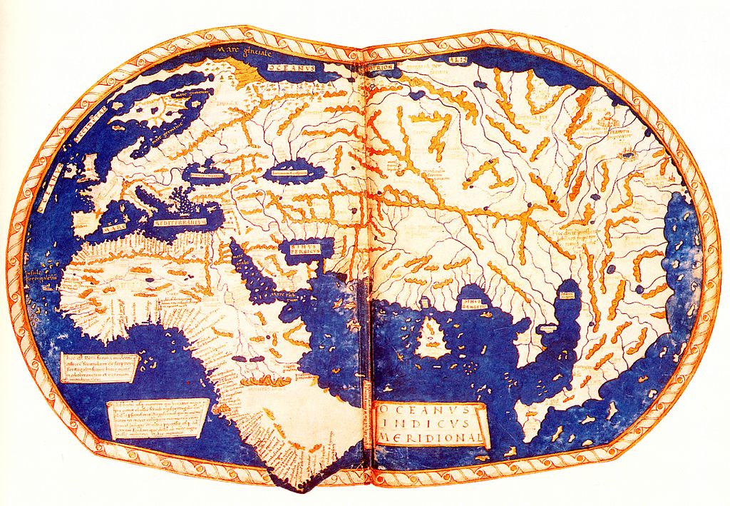
Photo Credit: 1)Heinrich Hammer the German ("Henricus Martellus Germanus")Ptolemy (Κλαύδιος Πτολεμαῖος, Claudius Ptolemaeus) / Public domain
Popular this Week


 Sponsor your Favorite Page
 SEARCH Search for: Search CLICK to LEAVE a TIP for our SERVICE. THANK YOUJoin – The JOM Membership Program
Become a Patron!
Sponsor a Masterpiece with YOUR NAME CHOICE for $5
Museums, Art & Historic Sites -Virtual Tours 🌐Follow
Virtual Tour of Camille Pissarro
https://joyofmuseums.com/artists-index/camille-pissarro/
"A Regatta on the Grand Canal" by Canaletto
https://joyofmuseums.com/museums/united-kingdom-museums/london-museums/the-national-gallery-london/masterpieces-of-the-national-gallery/a-regatta-on-the-grand-canal-by-canaletto/
“Only two things are infinite, the universe and human stupidity,
and I’m not sure about the former.”– Albert Einstein
https://joyofmuseums.com/museums/united-kingdom-museums/london-museums/the-national-gallery-london/masterpieces-of-the-national-gallery/an-experiment-on-a-bird-in-the-air-pump-by-joseph-wright-of-derby/
“Street in Venice” by John Singer Sargent
https://joyofmuseums.com/artists-index/john-singer-sargent/street-in-venice-by-john-singer-sargent/
The Hands of Rodin and Rose who he married in the last year of both their lives.
https://joyofmuseums.com/museums/united-states-of-america/philadelphia-museums/rodin-museum/masterpieces-of-the-rodin-museum/two-hands/
Share this:
- Tweet
